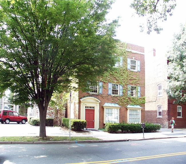
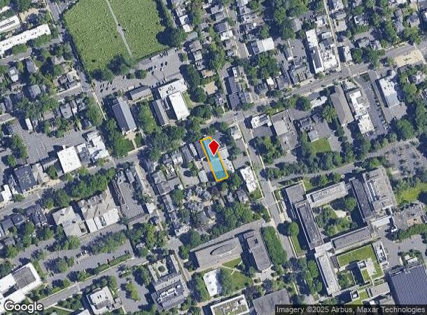
Property Record
221 Nassau St, Princeton, NJ 08542
NEARBY LISTINGS FOR SALE OR LEASE
Property Detail
221 Nassau St
14-00047-02-00026
B-47,L-26
Publicschool
Mercer
X
New Jersey
34021C0132F
26
0
0.21 AC
2025
Trenton North
0045011019
Northern New Jersey
550 SF
Trenton, NJ
DEMOGRAPHICS near 221 Nassau St
1 Mile
3 Mile
5 Mile
2024 Total Population
12,387
42,294
89,378
2029 Population
12,412
42,443
89,036
Pop Growth 2024-2029
+ 0.20%
+ 0.35%
(0.38%)
Average Age
40
41
40
2024 Total Households
4,796
15,807
32,879
HH Growth 2024-2029
+ 0.29%
+ 0.51%
(0.33%)
Median Household Inc
$136,202
$142,310
$156,487
Avg Household Size
2.40
2.50
2.60
2024 Avg HH Vehicles
2.00
2.00
2.00
Median Home Value
$823,938
$774,748
$722,135
Median Year Built
1956
1983
1986
Nearby Places
Map Layers
Map Styles
 Street
 Aerial
- Restaurants
- Banks
- Shops
- Fitness
- Groceries
PUBLIC TRANSPORTATION
TRANSIT/SUBWAY
Princeton (Princeton Branch - NJ Transit Commuter Rail (NJ Transit))
DRIVE
WALK
Distance
Princeton (Princeton Branch - NJ Transit Commuter Rail (NJ Transit))
2 min
16 min
0.8 mi
COMMUTER RAIL
Princeton (Princeton Branch - NJ Transit Commuter Rail (NJ Transit))
DRIVE
WALK
Distance
Princeton (Princeton Branch - NJ Transit Commuter Rail (NJ Transit))
3 min
16 min
0.8 mi
Princeton Junction (Northeast Corridor Line - NJ Transit Commuter Rail (NJ Transit), Princeton Branch - NJ Transit Commuter Rail (NJ Transit))
DRIVE
WALK
Distance
Princeton Junction (Northeast Corridor Line - NJ Transit Commuter Rail (NJ Transit), Princeton Branch - NJ Transit Commuter Rail (NJ Transit))
8 min
3.4 mi
AIRPORT
Trenton Mercer
DRIVE
WALK
Distance
Trenton Mercer
24 min
14.5 mi
Newark Liberty International
DRIVE
WALK
Distance
Newark Liberty International
61 min
41.9 mi
Freight Ports
New York Container Terminal
DRIVE
WALK
Distance
New York Container Terminal
55 min
37.0 mi
Nearby Properties
Address
Land Use
TOTAL SIZE
Lot Size
Zoning
Address
Land Use
TOTAL SIZE
Lot Size
Zoning
636,000 SF
60.76 AC
PHCR
Address
Land Use
TOTAL SIZE
Lot Size
Zoning
58.63 AC
PMUD
Address
Land Use
TOTAL SIZE
Lot Size
Zoning
492,110 SF
58.48 AC
I100
Address
Land Use
TOTAL SIZE
Lot Size
Zoning
Address
Land Use
TOTAL SIZE
Lot Size
Zoning
Address
Land Use
TOTAL SIZE
Lot Size
Zoning
30.62 AC
E
Address
Land Use
TOTAL SIZE
Lot Size
Zoning
24.85 AC
E
Address
Land Use
TOTAL SIZE
Lot Size
Zoning
62.22 AC
PRN1
Address
Land Use
TOTAL SIZE
Lot Size
Zoning
50.08 AC
PMUD
Address
Land Use
TOTAL SIZE
Lot Size
Zoning
23.76 AC
R5A
Address
Land Use
TOTAL SIZE
Lot Size
Zoning
265,000 SF
4.84 AC
Address
Land Use
TOTAL SIZE
Lot Size
Zoning
34.97 AC
PMUD
Address
Land Use
TOTAL SIZE
Lot Size
Zoning
23.64 AC
PMUD
Address
Land Use
TOTAL SIZE
Lot Size
Zoning
24.38 AC
ROM2
Address
Land Use
TOTAL SIZE
Lot Size
Zoning
8.97 AC
HMC
Address
Land Use
TOTAL SIZE
Lot Size
Zoning
25.66 AC
PHCR
Address
Land Use
TOTAL SIZE
Lot Size
Zoning
44.62 AC
R5A
Address
Land Use
TOTAL SIZE
Lot Size
Zoning
115,000 SF
7.98 AC
OR2
Address
Land Use
TOTAL SIZE
Lot Size
Zoning
405,811 SF
4.14 AC
Address
Land Use
TOTAL SIZE
Lot Size
Zoning
17.17 AC
PMN
Address
Land Use
TOTAL SIZE
Lot Size
Zoning
18.52 AC
ROM2
Address
Land Use
TOTAL SIZE
Lot Size
Zoning
216,000 SF
22.79 AC
SC
Address
Land Use
TOTAL SIZE
Lot Size
Zoning
27.69 AC
B-2
Address
Land Use
TOTAL SIZE
Lot Size
Zoning
66.62 AC
PMUD
Address
Land Use
TOTAL SIZE
Lot Size
Zoning
258,277 SF
5.96 AC
Address
Land Use
TOTAL SIZE
Lot Size
Zoning
2.49 AC
E3
Address
Land Use
TOTAL SIZE
Lot Size
Zoning
0.78 AC
PHCR
Address
Land Use
TOTAL SIZE
Lot Size
Zoning
11.75 AC
PMUD
Address
Land Use
TOTAL SIZE
Lot Size
Zoning
8.27 AC
PMUD
Address
Land Use
TOTAL SIZE
Lot Size
Zoning
2.29 AC
The World's #1 Commercial Real Estate Marketplace
Connect with us
© 2025 CoStar Group
The information above has been obtained from sources believed reliable. While we do not doubt its accuracy we have not verified it and make no guarantee, warranty or representation about it. It is your responsibility to independently confirm its accuracy and completeness. Any projections, opinions, assumptions, or estimates used are for example only and do not represent the current or future performance of the property. The value of this transaction to you depends on tax and other factors which should be evaluated by your tax, financial, and legal advisors. You and your advisors should conduct a careful, independent investigation of the property to determine to your satisfaction the suitability of the property for your needs.